URGENT UPDATE: A severe thunderstorm warning has just been issued for parts of the Riverina as a vigorous icy blast sweeps through the region, creating hazardous conditions. The Bureau of Meteorology announced the alert shortly before 2:30 PM today, August 29, impacting areas from Hay and Deniliquin in the west to Narrandera and Albury in the east.
As of 3:30 PM, Wagga was not yet included in the warning, but forecasters anticipate that it will likely experience damaging winds later this afternoon. The cold front is expected to bring showers, storms, and severe winds across southern New South Wales.
The Bureau has warned that severe thunderstorms could produce damaging winds in the warning area over the next several hours. Areas that may be affected include Albury, Griffith, and Corowa.
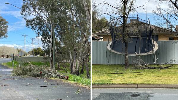
Wind gusts have already reached up to 98 km/h at Hay Airport at 2:06 PM, with Deniliquin reporting 87 km/h just before 2 PM. Reports from Deniliquin indicate significant debris, including downed tree branches and a trampoline blown onto a nature strip. As the storm progresses, a gust of 82 km/h was recorded in Narrandera at 3:20 PM.
Residents of Wagga should prepare for a high chance of rain and possible thunderstorms this afternoon, including small hail. The State Emergency Service (SES) urges the public to secure loose items around their homes and park vehicles away from trees to avoid damage.
Additionally, a sheep graziers warning has been issued for the Riverina and South West Slopes, predicting cold temperatures and rain that could threaten livestock. The Bureau cautioned that there is a risk of losing lambs and sheep exposed to these conditions.
Snow showers are also forecast for the southern ranges above 700 metres, with potential snowfall in higher areas of the Riverina, including around Batlow and Laurel Hill. Following the front, temperatures will plummet, with a high of only 12 degrees expected in Wagga on Saturday.
For emergency assistance during floods and storms, residents are advised to contact the SES at 132 500. Stay tuned for further updates as this developing situation unfolds.


